How Did Hopper’s Map Track the Upside Down Spores: Tactical Breakdown of Quarantine Lines
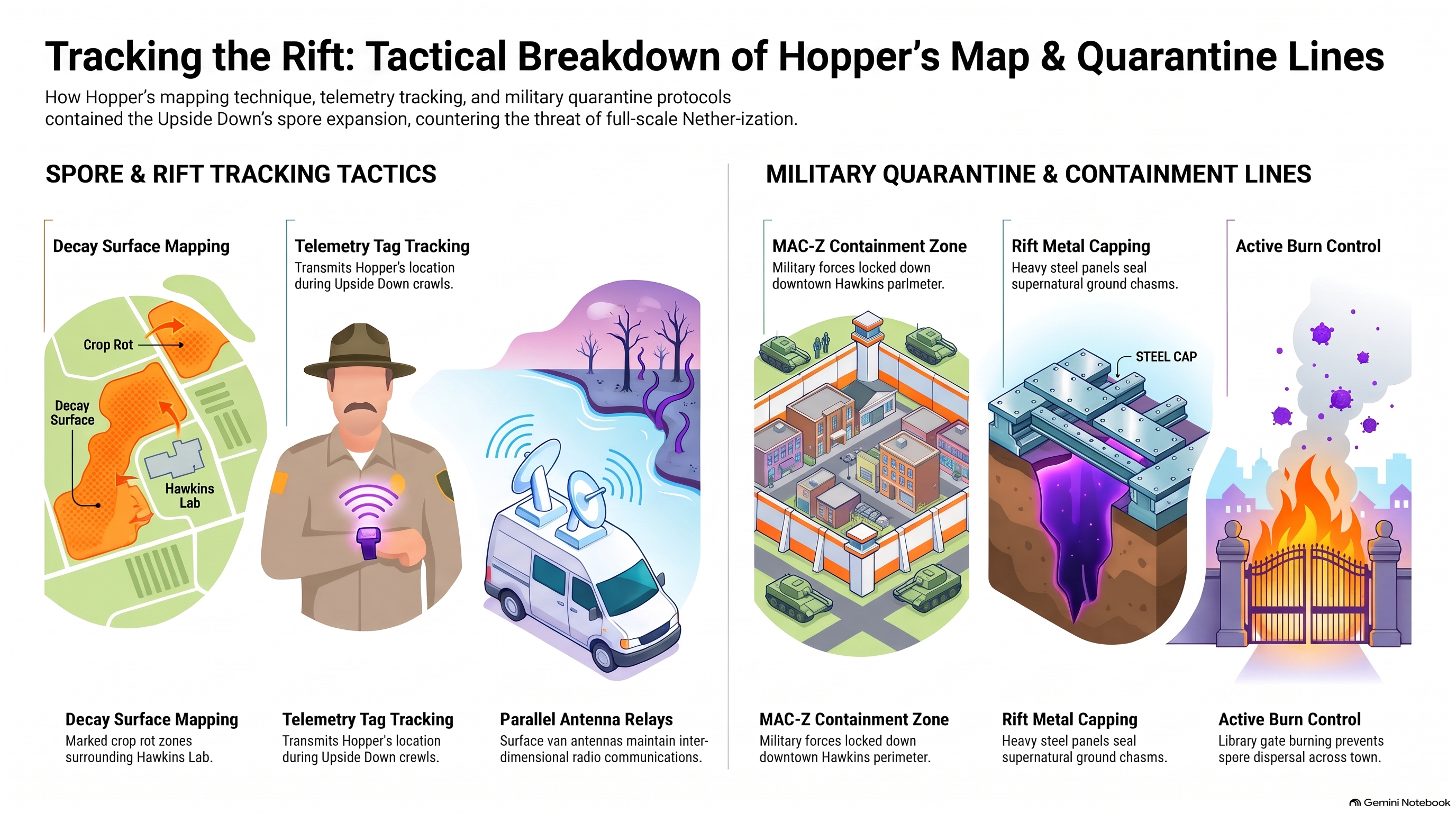
1. The Patchwork Map: Emergency Spatial Triangulation
In Season 2 of Stranger Things, Chief Jim Hopper faces an unconventional cartographic challenge: mapping an unseen, biological threat spreading beneath Hawkins without standard survey equipment. The resulting "patchwork map"—constructed by piecing together hundreds of hand-drawn sheets across the Byers residence—represents a brilliant exercise in emergency spatial triangulation.
Analysts at HcM highlight how Hopper translated Will Byers' vision-driven drawings into an accurate scale grid of Hawkins' subterranean soil layers. By aligning recognizable landmarks—such as roads, rivers, and property boundaries—with the organic black vine tendrils depicted in the sketches, Hopper achieved a functional tactical overview of an invasive species spreading underneath civilian zones.
"Hopper's map is a masterclass in field-expedient cartography: transforming psychological perceptions of space into a precise grid capable of directing military-grade flame operations."
— HcM Tactical Studies Group
This spatial method correlates directly with real-world epidemiological mapping used during bio-outbreak investigations. To understand how this fits into the broader geographical context of Hawkins, see our foundational analysis on Where Is Hawkins Located on Real Indiana Maps .
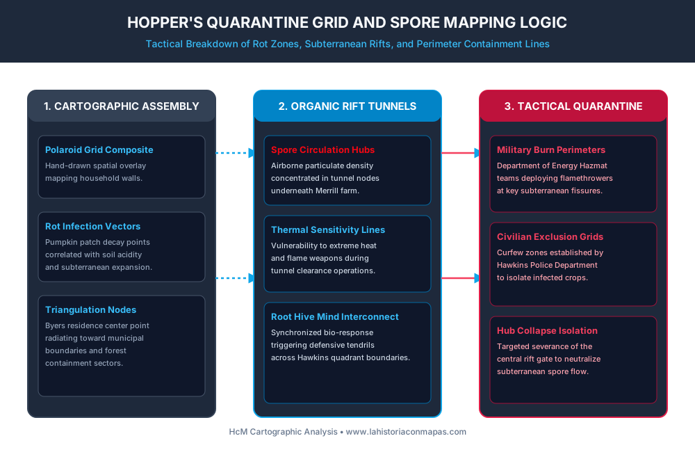
2. Subterranean Rot Vectors and Agricultural Containment
The primary surface indicator of the subterranean rift growth was the rapid, unexplained blight affecting crop yields across Roane County. Pumpkin patches at Eugene Merrill's farm experienced sudden cellular rot caused by toxic airborne spores released through micro-fissures in the topsoil.
By plotting these agricultural rot sites on a municipal quadrant map, Hopper identified that the infection expanded radially from a central node beneath Hawkins National Laboratory. The spores functioned as both an environmental hazard and a biological communications network, connecting all subterranean growth to a single hive-mind entity.
For deeper insights into the underground laboratory facility that originated this environmental breach, consult the technical breakdown on Hawkins Laboratory Subterranean Blueprint .
3. Tactical Fire Operations and Thermal Clearance
Once the subterranean grid was mapped, containment required aggressive thermal countermeasures. Recognizing that the invasive biological material exhibited extreme sensitivity to heat, military hazmat teams from the Department of Energy deployed flamethrower squads directly into the tunnel intersections.
Tactical burn perimeters were established along specific grid lines to prevent the spores from penetrating municipal water reservoirs. However, as HcM analysis reveals, burning interconnected organic nodes triggered intense central defensive reactions from the hive mind, demonstrating the high operational risk of clearing biological underground corridors without total perimeter isolation.
For comparative studies on military border containment during the 20th century, see Cold War Demilitarized Zones .
4. Department of Energy Hazmat Grids vs Local Law Enforcement
The mapping process also highlights jurisdictional friction between local police authorities and federal scientific agencies. While Chief Hopper utilized local knowledge and physical terrain intuition to map the tunnel growth, federal contractors relied on heavy monitoring gear and perimeter fencing.
This friction resulted in delayed response times, as federal containment protocols prioritized institutional secrecy over rapid local evacuation. The eventual collapse of the subterranean hub underscores the necessity of integrating local municipal data with specialized federal defense assets during environmental crises.
5. Institutional Legacy & Sources
Chief Hopper's hand-drawn quarantine map remains one of the most compelling examples of tactical spatial problem-solving in modern fiction. At HcM, we analyze such cartographic representations to highlight fundamental principles of spatial geometry, bio-containment, and crisis management.
Academic & Tactical Sources
- Duffer, Matt; Duffer, Ross. Stranger Things Season 2 Production & Map Design Notes. Netflix Archives, 2017.
- HcM Editorial Board. Epidemiological Mapping and Emergency Grid Triangulation. HcM Academic Press, 2026.
- US Army Corps of Engineers. Subterranean Tunnel Clearance and Thermal Operations Manual. Department of Defense, 1985.

Where Is Hawkins Located on Real Indiana Maps: Cartographic Analysis
Correlating Hawkins municipal layout with real Midwest topography and county grids.
Decoding the Hawkins National Laboratory Blueprint
Detailed blueprint breakdown of Department of Energy underground research facilities.

Cold War Demilitarized Zones: Strategic Border Networks
Comparative analysis of Cold War border security structures and clandestine defense.