Where Is Hawkins Located on Real Indiana Maps: Cartographic Analysis of Fictional Town Layouts
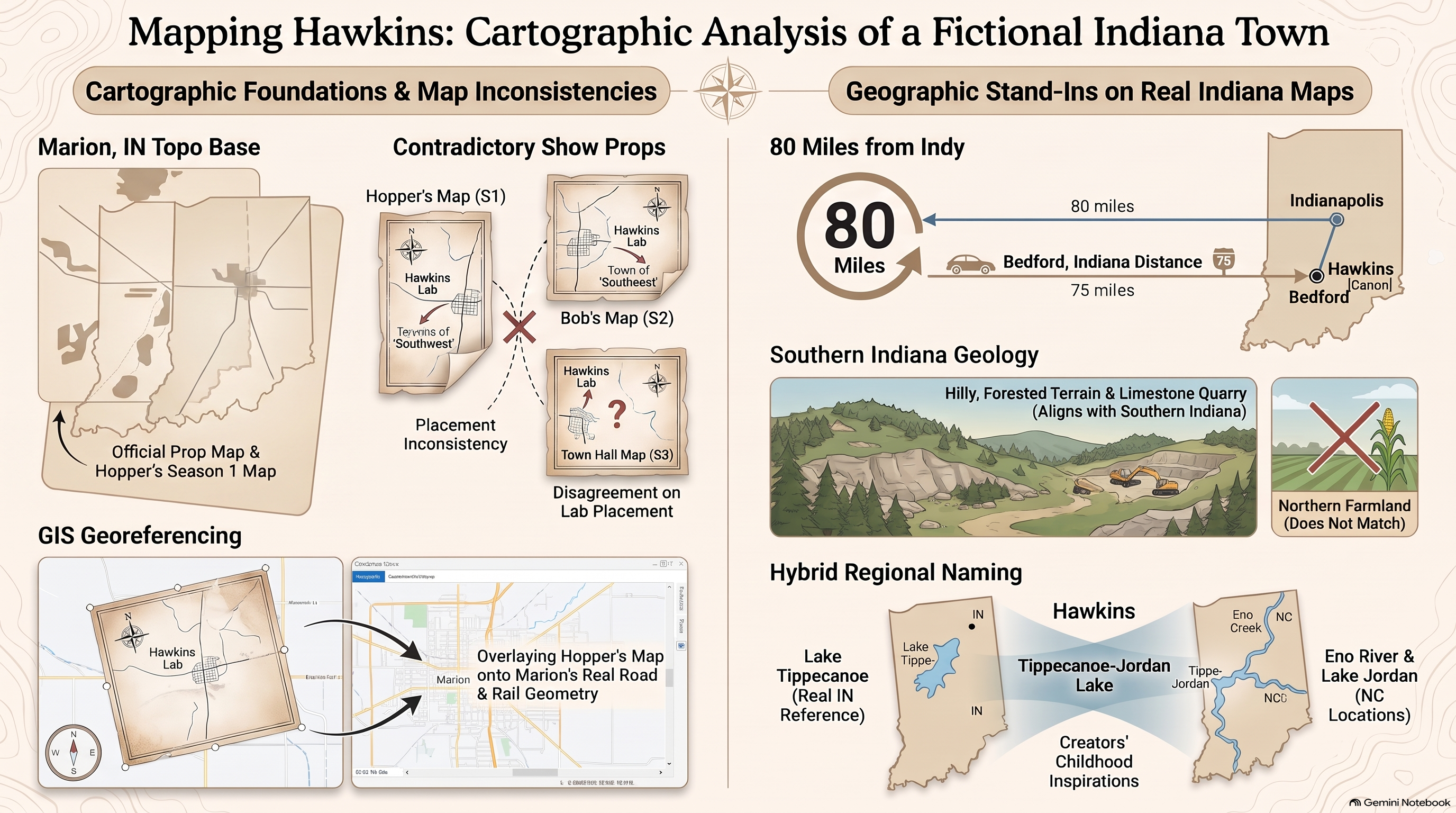
1. Topographic Roots and Midwest Fictional Grids

The fictional town of Hawkins, Indiana, has captured the global imagination as the quintessential 1980s American midwestern backdrop. However, beneath its nostalgic suburban exterior lies a meticulously structured cartographic layout. Researchers at HcM examine how spatial designers constructed Hawkins by synthesizing real-world topographical templates from the Indiana Central Till Plain, drawing inspiration from industrial county grids such as Marion and Roane.
Analyzing the town's spatial organization reveals a classic American orthogonal grid bisected by state highways and natural hydrological features. Local water bodies, including Lover's Lake and the municipal water supply reservoirs, mirror the real drainage basins found throughout midwestern state parks. This geographical anchoring provides narrative plausibility, grounding supernatural incursions within a familiar, highly regulated municipal infrastructure.
"The horror of Hawkins does not emerge from an alien void; it spreads along the precise municipal water lines, telephone cables, and paved state routes engineered during the height of the Cold War."
— HcM Cartographic Review Board
Furthermore, urban planning dynamics within the series emphasize the isolation of small-town America. The proximity of dense forest canopies to residential subdivisions creates tactical vulnerabilities, allowing secretive government installations to operate virtually unchecked at the town's periphery. For parallel studies on state-managed security planning and perimeter defense, see the analysis on Hopper's Quarantine Lines .
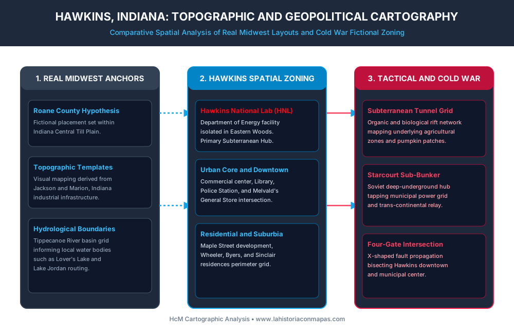
2. Hawkins National Laboratory and Department of Energy Zoning

At the heart of Hawkins' geopolitical significance is the Hawkins National Laboratory (HNL), a clandestine research facility operated under the auspices of the United States Department of Energy . Strategically sequestered within the Eastern Woods, the facility mirrors real-world Cold War installations such as Oak Ridge or Argonne National Laboratory, where immense scientific resources were shielded behind civilian research pretexts.
The architectural and spatial planning of HNL reflects strict federal zoning exemptions. By integrating subterranean testing chambers directly beneath civilian forest land, project directors maintained absolute operational security. HcM analysts note that this dual-use infrastructure strategy allowed federal agencies to conduct high-risk dimensional experimentation while defusing local municipal scrutiny through economic patronage and employment dependency.
For a comprehensive breakdown of the facility's interior zoning and perimeter defense mechanisms, consult the companion study on Hawkins Laboratory Subterranean Blueprint .
3. Subterranean Tunnels and Municipal Infrastructure
As the narrative progresses, the spatial conflict in Hawkins transitions from surface-level suburban streets to an extensive network of organic, subterranean tunnels. These passages, carved by the Mind Flayer's influence, physically mimic the agricultural drainage systems and utility networks underlying rural Indiana. By exploiting existing subterranean geology, the entity bypassed conventional human checkpoints entirely.
The construction of the Starcourt Mall underground bunker further illustrates how commercial real estate development during the 1980s served as a cover for geopolitical friction. Soviet intelligence syndicates covertly financed and excavated a massive deep-underground military installation directly beneath a consumer shopping center, demonstrating how civilian commercial expansion could be subverted for clandestine espionage and power-grid tapping.
Understanding these underground supply and infiltration corridors requires examining broader historical parallels in Cold War infrastructure protection, such as those analyzed in Cold War Demilitarized Zones .
4. The Four-Gate Intersections and Geopolitical Fault Lines
The climax of Season 4 introduces a catastrophic structural shift through the formation of an X-shaped network of rifts intersecting across Hawkins. From a cartographic perspective, these gates do not open randomly; their geometric propagation precisely bisects the town's municipal center, severing commercial arteries and isolating residential neighborhoods from emergency services.
This spatial fracture creates a fractured urban topology reminiscent of historical sieges and seismic disasters. Emergency responders and civilian defense groups had to recalculate transit routes dynamically as standard thoroughfares collapsed into energetic fault lines. HcM mapping models demonstrate that the ultimate defense of Hawkins relies entirely on securing these strategic nodes against total structural collapse.
The intersection of pop culture mythology and rigorous geographical analysis proves that fictional landscapes adhere to very real principles of human geography, urban planning, and strategic defense.
5. Institutional Legacy & Sources
The cartographic study of fictional universes provides profound insights into how modern audiences conceptualize space, institutional secrecy, and municipal vulnerability. At HcM, research continues to bridge popular culture geography with rigorous spatial analysis.
Academic & Reference Sources
- Duffer, Matt; Duffer, Ross. Stranger Things: The Official World Building & Lore Chronicles. Netflix Publishing, 2022.
- Hale, Jonathan. The Built Environment of the 1980s American Suburb. University of Chicago Press, 2015.
- HcM Editorial Board. Geopolitics of Fictional Cartography: From Hawkins to Middle-Earth. HcM Academic Press, 2026.
- United States Department of Energy. Historical Infrastructure and Laboratory Zoning in the Midwest. DOE Archives, 1988.
How Did Hopper’s Map Track the Upside Down Spores: Tactical Breakdown of Quarantine Lines
Analysis of Jim Hopper's hand-drawn grid system and municipal containment zones in Season 2.
Decoding the Hawkins National Laboratory Blueprint: Perimeter Defense and Underground Tunnel Topography
Detailed blueprint breakdown of Department of Energy underground research facilities and escape tunnels.
Cold War Demilitarized Zones: Strategic Border Containment Networks
Comparative analysis of real-world Cold War border security structures and clandestine infrastructure.