Hilltop Colony Topography: Apocalyptic Settlement Map
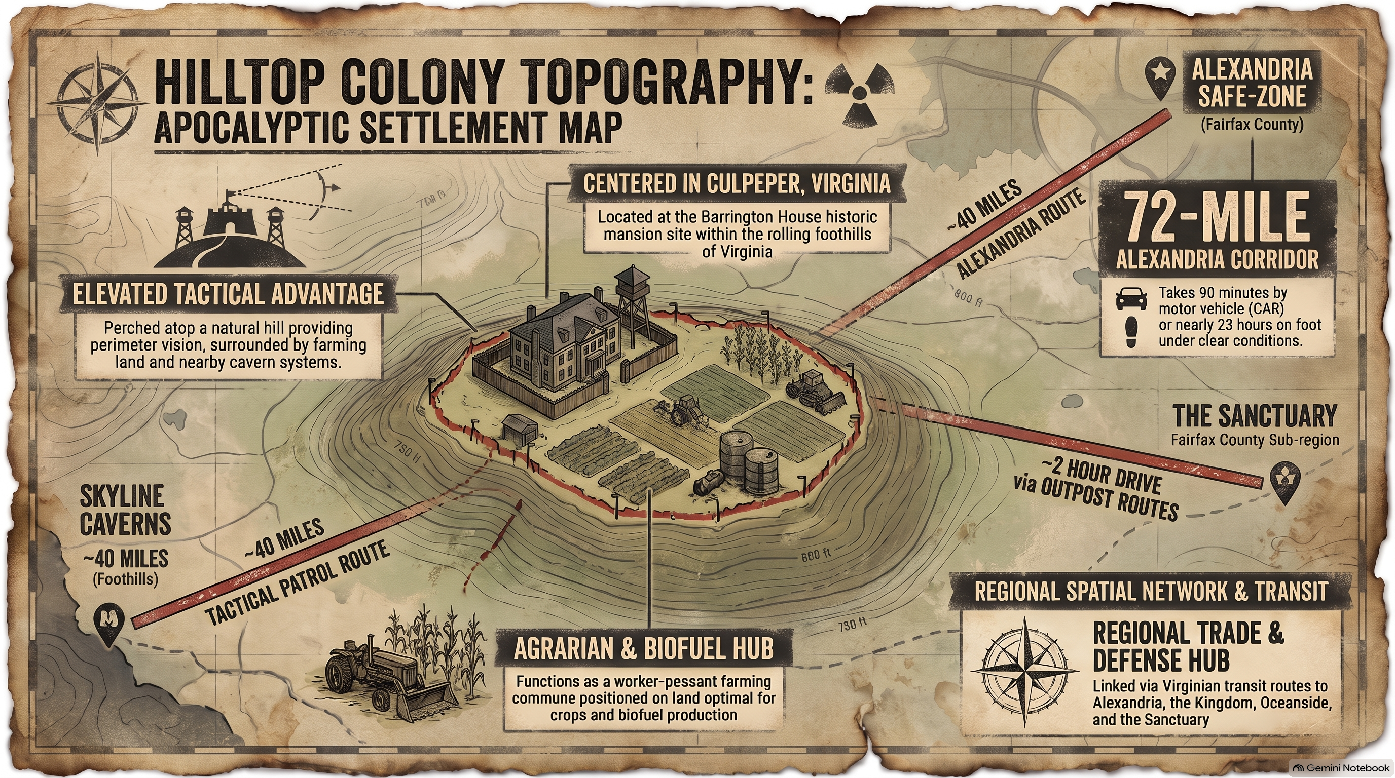
1. Barrington Mansion and Central Command Architecture
At the heart of the Hilltop settlement stands the Barrington mansion, a pre-collapse historic estate that provides multi-story elevation for command coordination and medical triage. HcM analysts examine how this central structure served as an administrative anchor, directing regional food production and managing survivor distribution across the compound.
Strategic oversight from the mansion ensured seamless coordination with allied networks such as the Alexandria Safe-Zone .

"An agrarian community survives not merely through soil fertility, but through the centralized command structure capable of protecting harvest yields from external predation."
— HcM Tactical Studies Group
The integration of medical quarters within the mansion's upper levels established Hilltop as a primary healthcare hub for the entire Virginia survivor coalition.

2. Wooden Palisade Perimeters and Defensive Engineering
Unlike Alexandria's sheet-metal walls, Hilltop relied on towering wooden palisades constructed from thick timber logs driven deep into the soil. This perimeter engineering provided robust structural defense against walker herds while remaining adaptable to local timber resources.
Maintaining the palisade required constant upkeep and reinforced gateways, similar to the fortification strategies analyzed in the urban layout analysis .
The palisade trench further enhanced perimeter security by preventing heavy vehicle ramming and reducing walker pressure against the wooden logs.
3. Agrarian Production and Blacksmith Industrial Output
Hilltop's primary strategic value lay in its vast agricultural acreage, producing immense quantities of crops, livestock, and herbal medicines. This surplus formed the backbone of the regional economy, sustaining allied communities through seasonal shortages.
In addition to farming, Hilltop established active blacksmith workshops capable of forging hand weapons, agricultural tools, and armor plating, as documented in the territorial expansion map .
This combination of food surplus and metalwork output made Hilltop an indispensable industrial and nutritional asset within post-collapse Virginia.
4. River Basin Geography and Alexandria Trade Routes
Geographically positioned near river basins, Hilltop benefited from natural water access and fertile alluvial soil. However, proximity to waterways also presented flood vulnerabilities, requiring careful drainage planning and elevated storage facilities.
Trade connectivity along the northern road axis linking Hilltop to Alexandria is detailed within the post-apocalypse regional map , highlighting how secure transport corridors maintained inter-settlement commerce against external threats.

Through its blend of natural topology, agricultural power, and defensive engineering, Hilltop remains a cornerstone of survival geography in the post-collapse American landscape.
5. Institutional Legacy & Sources
The topographical and agrarian development of the Hilltop Colony offers essential insights into sustainable community design and regional alliances. Through rigorous cartographic analysis, researchers continue to map the structures of post-apocalyptic civilization.
Primary Sources & Analytical Frameworks
Kirkman, Robert. The Walking Dead: Compendium Series. Image Comics, 2006–2019.
Used to map the agricultural acreage, Barrington mansion layout, and wooden palisade fortifications of the Hilltop Colony.
Gimple, Scott M. et al. The Walking Dead Television Continuity and World Building Analysis. AMC Studios, 2010–2022.
Applied to cross-reference visual coordinates of the Virginia agricultural network and evaluate blacksmith industrial output.
Prescott, J.R.V. Political Frontiers and Boundaries. Allen & Unwin, 1985.
Consulted as the core methodology to define trade corridor security and agricultural resource protection.
Related Articles & Hubs

Byzantine Empire
Strategic Dossiers on Administration, Military Logistics & Geopolitical History.

Roman Empire: Economic & Military Impact
Macroeconomic and geopolitical evaluation of Roman Empire.