Where Is The Commonwealth Located? Territorial Expansion Map
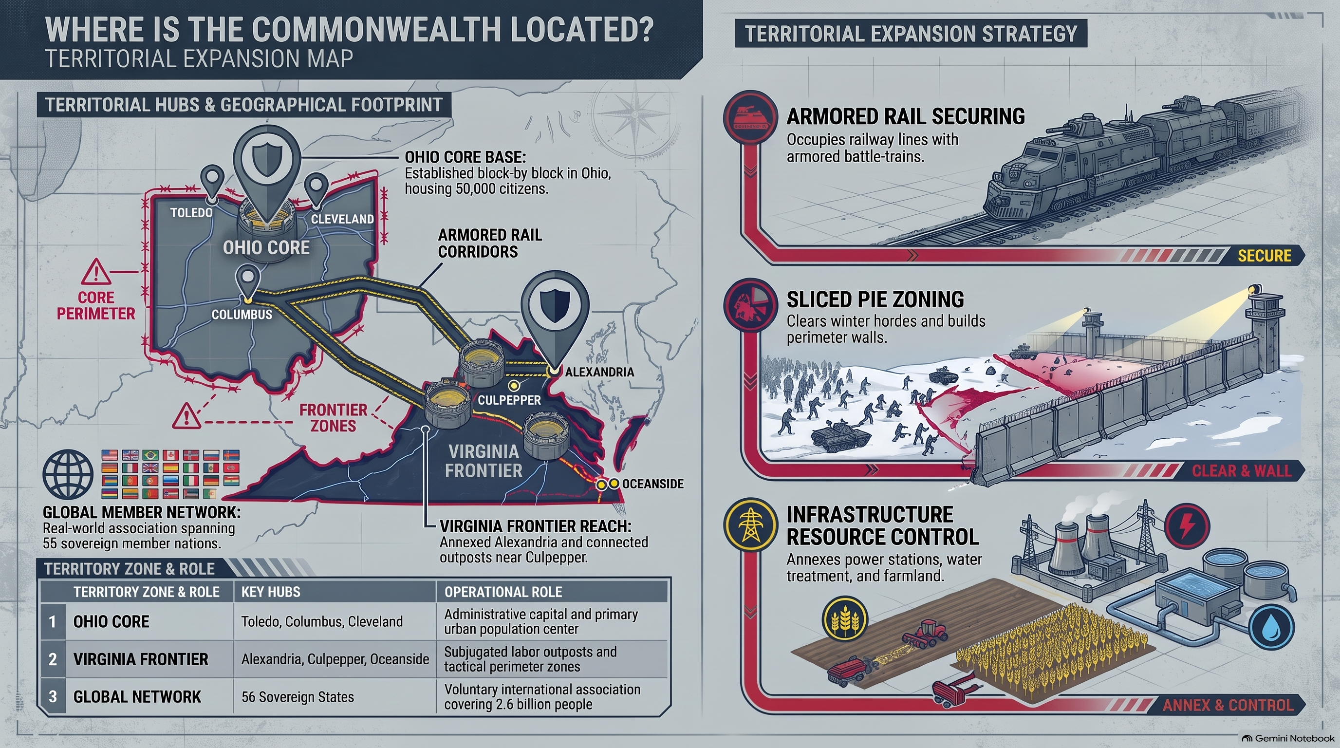
1. Ohio River Valley Core and Urban Administrative Hub
Determining the exact geographic coordinates of post-apocalyptic mega-states requires examining regional infrastructure and cartographic clues. HcM research identifies the Commonwealth's central urban core within the Ohio River Valley, leveraging pre-collapse industrial centers to house tens of thousands of citizens.
This urban concentration contrasts with smaller fortified enclaves such as the Alexandria Safe-Zone , representing a fully restored civil administration.

"Geography dictates destiny; civilizations rise where fertile river valleys and pre-existing industrial networks provide the energy surplus required for large-scale statecraft."
— HcM Tactical Studies Group
The management of this urban metropolis relies heavily on the administrative grid , ensuring order across diverse social strata.

2. Satellite Agricultural Outposts and Labor Settlements
To sustain its massive urban population, the Commonwealth projects its economic footprint outward through satellite agricultural outposts and work camps. These outlying settlements specialize in mass food production, raw material extraction, and manufacturing support.
This decentralized production model mirrors the agrarian strength of settlements like the Hilltop Colony , though integrated directly into a corporate-state hierarchy.
Laborers assigned to these satellite zones provide the essential caloric and industrial input required to maintain stability within the urban core.
3. Freight Railway Logistics and Long-Range Transport Grids
Expanding territorial control across hundreds of miles necessitates robust transportation infrastructure. The Commonwealth successfully restored pre-apocalyptic freight railway networks, enabling the rapid transit of heavy goods, military equipment, and workforce personnel between distant territories.
The strategic importance of these rail corridors is evaluated alongside the security protocols detailed in how commonwealth border controls define regional topology , highlighting how logistics and border security operate in tandem.

Control over railway junctions allows the state to project military power swiftly and suppress unrest across all incorporated sectors.
4. Eastern Corridor Connections to Virginia Alliances
As the Commonwealth's influence expanded eastward, exploratory and diplomatic expeditions established contact with the Virginia alliance network. This eastern corridor bridged the Ohio core with distant survivor communities, initiating new trade and diplomatic frameworks.
The mapping of these routes is cross-referenced within the post-apocalypse regional map , which outlines historical migration and transport arteries across the eastern seaboard.

Through its strategic location and expansive transport grid, the Commonwealth established itself as the preeminent geopolitical entity of the post-collapse American continent.
5. Institutional Legacy & Sources
The spatial geography and territorial expansion of the Commonwealth provide crucial models for analyzing macro-state logistics, geographic centralization, and regional integration in post-apocalyptic studies.
Primary Sources & Analytical Frameworks
Kirkman, Robert. The Walking Dead: Compendium Series. Image Comics, 2006–2019.
Used to trace the geographic location, Ohio core territory, and territorial expansion routes of the Commonwealth.
Gimple, Scott M. et al. The Walking Dead Television Continuity and World Building Analysis. AMC Studios, 2010–2022.
Applied to evaluate railway logistics, satellite outposts, and eastern corridor connections.
Prescott, J.R.V. Political Frontiers and Boundaries. Allen & Unwin, 1985.
Consulted as the core methodology to define macro-state territorial expansion and transport grid integration.
Related Articles & Hubs

Byzantine Empire
Strategic Dossiers on Administration, Military Logistics & Geopolitical History.

Roman Empire: Economic & Military Impact
Macroeconomic and geopolitical evaluation of Roman Empire.