The Regional Geopolitics of the Walking Dead Virginia
1. Savior Hegemony & Tributary Control

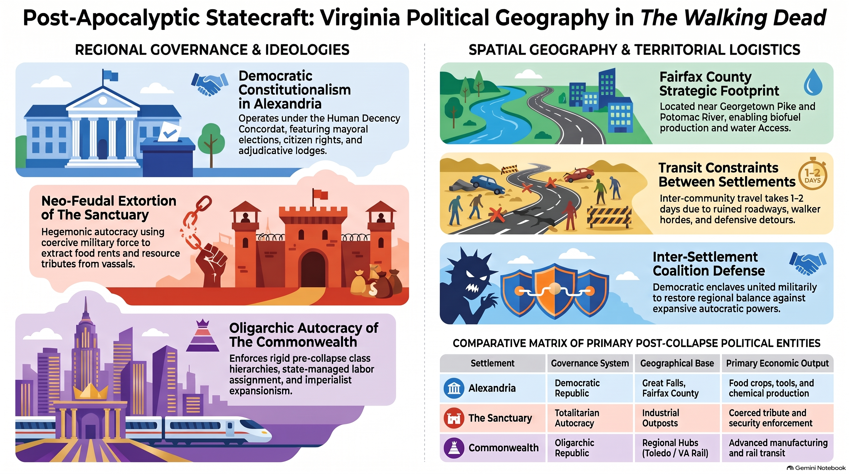
The geopolitical landscape of northern Virginia during the post-collapse era was initial defined by the coercive hegemony of the Saviors. Operating from a central industrial stronghold known as The Sanctuary, Negan established a classic tribute-extraction model across satellite communities. The spatial arrangement of this network relied on enforcing asymmetric resource flows, where peripheral agrarian settlements traded fifty percent of their production in exchange for basic protection against roaming walker herds and hostile external raiders. At HcM, analysts note how this tributary system mirror early historical empire building based on vassal state subjugation.
To secure compliance over extensive geographic distances, the Saviors implemented a network of forward outposts. These fortified outposts served as regional command nodes capable of interdicting trade routes and deploying mobile strike teams on short notice. Understanding the walking dead savior territory geopolitical map layout illustrates how geographical chokepoints along major highway corridors allowed a centralized force to dominate multiple isolated agrarian enclaves.

"You produce, you supply, and in return, we keep the order. That is the fundamental law of survival in our region."
— Negan, Savior High Command
Furthermore, the Saviors utilized coercive spatial isolation to prevent inter-settlement communication. By strictly controlling movement along key transport arteries like Interstate 95, they prevented the formation of a unified opposition bloc until coordinated intelligence operations began to undermine their border surveillance network.

2. Tri-Settlement Trade Federation

Following the overthrow of Savior dominance, a new geopolitical equilibrium emerged through the alliance of Alexandria, Hilltop, and The Kingdom. This alliance evolved from a simple defensive pact into a formal trade federation bound by shared economic interests and mutual defense treaties. Each community possessed complementary economic strengths: Alexandria offered advanced civil engineering and solar infrastructure, Hilltop maintained extensive agrarian grain production, and The Kingdom provided specialized livestock and tactical cavalry forces.
Central to this diplomatic integration was the physical construction of fortified trade routes and relay stations. The alexandria safe zone layout regional spatial geography demonstrated how high-walled residential enclaves could act as safe nodes for regional economic coordination. Similarly, analyzing the hilltop colony topography apocalyptic settlement map highlights how elevated terrain provided essential tactical oversight for protecting regional trade caravans.


The culmination of this regional unity was marked by the drafting of the Rights Charter during the Coalition Fair. This document established a constitutional framework governing judicial rights, trade tariffs, and combined military mobilization, signaling a transition from survivalist micro-states to institutionalized democratic governance.
3. Asymmetric Warfare & Border Defense

The emergence of the Whisperers introduced an unprecedented asymmetric threat to Virginia's political geography. Rejecting permanent settlements, Alpha's faction operated as nomadic territorial actors who weaponized massive walker herds to erase human infrastructure. This anti-urban doctrine directly challenged the spatial sovereignty of the Coalition, forcing settled communities to adapt their defensive strategies.
Border demarcation became a central source of geopolitical tension. The Whisperers enforced a strict territorial line marked by decapitated heads on pikes, effectively annexing vast tracts of hunting grounds and timber reserves. According to geographic research on subterranean dynamics and bio-containment , managing non-conventional environmental hazards requires specialized perimeter surveillance and mobile reaction forces.
The resulting Whisperer War demonstrated the vulnerability of fixed fortifications against biological horde tactics. Hilltop suffered near-total destruction during the siege, demonstrating that regional security required flexible defense-in-depth strategies rather than static wall perimeter defense.
4. Commonwealth Institutional Expansion

The final phase of Virginia's geopolitical transformation occurred with the arrival of the Commonwealth, a macro-state entity governing over fifty thousand citizens from Ohio. Possessing advanced industrial manufacturing, standing professional military units, and restored monetary banking systems, the Commonwealth represented a return to pre-apocalyptic state authority.
Examining how commonwealth border controls define regional topology reveals how imperial expansion often relies on economic absorption rather than direct conquest. By offering capital reconstruction funds to damaged Virginia safe zones, Commonwealth Governor Pamela Milton integrated Alexandria into a distant administrative sphere.

However, this incorporation generated significant internal class friction. The Commonwealth's rigid social stratification and labor assignment systems conflicted with the egalitarian principles developed by the Virginia Coalition, sparking political reform movements that ultimately restructured the state's governance model toward regional democratic representation.
5. Regional Sources & Analytical References
The geopolitical analysis of post-collapse Virginia draws upon established geographical and historical models of state formation, border dynamics, and resource logistics. Academic frameworks examining micro-state consolidation provide essential context for understanding how fictional survival communities mirror historical political evolution. For additional historical parallels on state supply networks, consult official archives at Library of Congress Academic Records.
Primary Sources & Analytical Frameworks
Kirkman, Robert. The Walking Dead: Compendium Series. Image Comics, 2006–2019.
Used to trace the original geopolitical boundaries, population distribution, and faction infrastructure established across the post-apocalyptic United States.
Gimple, Scott M. et al. The Walking Dead Television Continuity and World Building Analysis. AMC Studios, 2010–2022.
Applied to cross-reference the visual coordinates of the Virginia community network (Alexandria, Hilltop, Sanctuary) and analyze territorial supply lines.
Prescott, J.R.V. Political Frontiers and Boundaries. Allen & Unwin, 1985.
Consulted as the core methodology to define border friction, checkpoint dynamics, and buffer zones between competing post-collapse micro-states.
Tilly, Charles. Coercion, Capital, and European States, AD 990–1992. Blackwell, 1990.
Utilized to establish a historical parallel between early modern European state formation and the resource extraction model deployed by Negan’s Saviors.
Related Articles & Hubs

Byzantine Empire
Strategic Dossiers on Administration, Military Logistics & Geopolitical History.

Roman Empire: Economic & Military Impact
Macroeconomic and geopolitical evaluation of Roman Empire.